Analysis & Prediction of Road Accident Data for NH-19/44
Main Article Content
Abstract
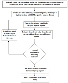
Increased traffic congestion in highways and urban areas with an increase in traffic accidents on road networks—which were never intended to handle the volumes and types of traffic they are now required to carry—are results of growing urbanisation and the rise in the number of vehicles in many developing countries. Unplanned urban growth has also resulted in a wide range of confrontations between vehicles and pedestrians, as well as incompatible land users. Many new urban residents are unaccustomed to such high traffic levels as a result of the migration from rural to urban areas. As a result, there has frequently been a considerable deterioration in driving conditions, as well as an increase in risks and rivalry between various groups of road users. Additionally, poor road upkeep, poorly designed junctions, and insufficient provisions for pedestrians frequently make the inherent dangers worse. The quantity of traffic on the roadways has been increasing recently, which has raised the likelihood of traffic accidents. Road traffic accidents are the fifth most major cause of mortality worldwide, according to evidence from both industrialised and developing nations, and they are on the rise. They are responsible for a sizable part of injuries, fatalities, and disabilities among the population. The route of NH 19/44 between Mathura and Agra has been chosen as the study area. The study span is 36 kilometres long in total. Aside from vehicles owned by the Transport Corporation, the majority of heavy vehicles that travel between Mathura and Agra are trucks transporting industrial items, containers, and vehicles used to transport construction materials. There are steel plants, textile mills, foundries, schools, colleges, banks, gas bunks, etc. on both sides of the stretch at regular intervals. Along the stretch under consideration, there were nine police stations. Information about the road inventory was gathered directly from the study stretch. The entire 67 km route was divided into three sections with various segment lengths based on the number of police stations and jurisdiction. Police stations are scattered throughout these parts, spaced 10 to 12 kilometres apart.

